Ascent of Mera Peak, 6,461 metres

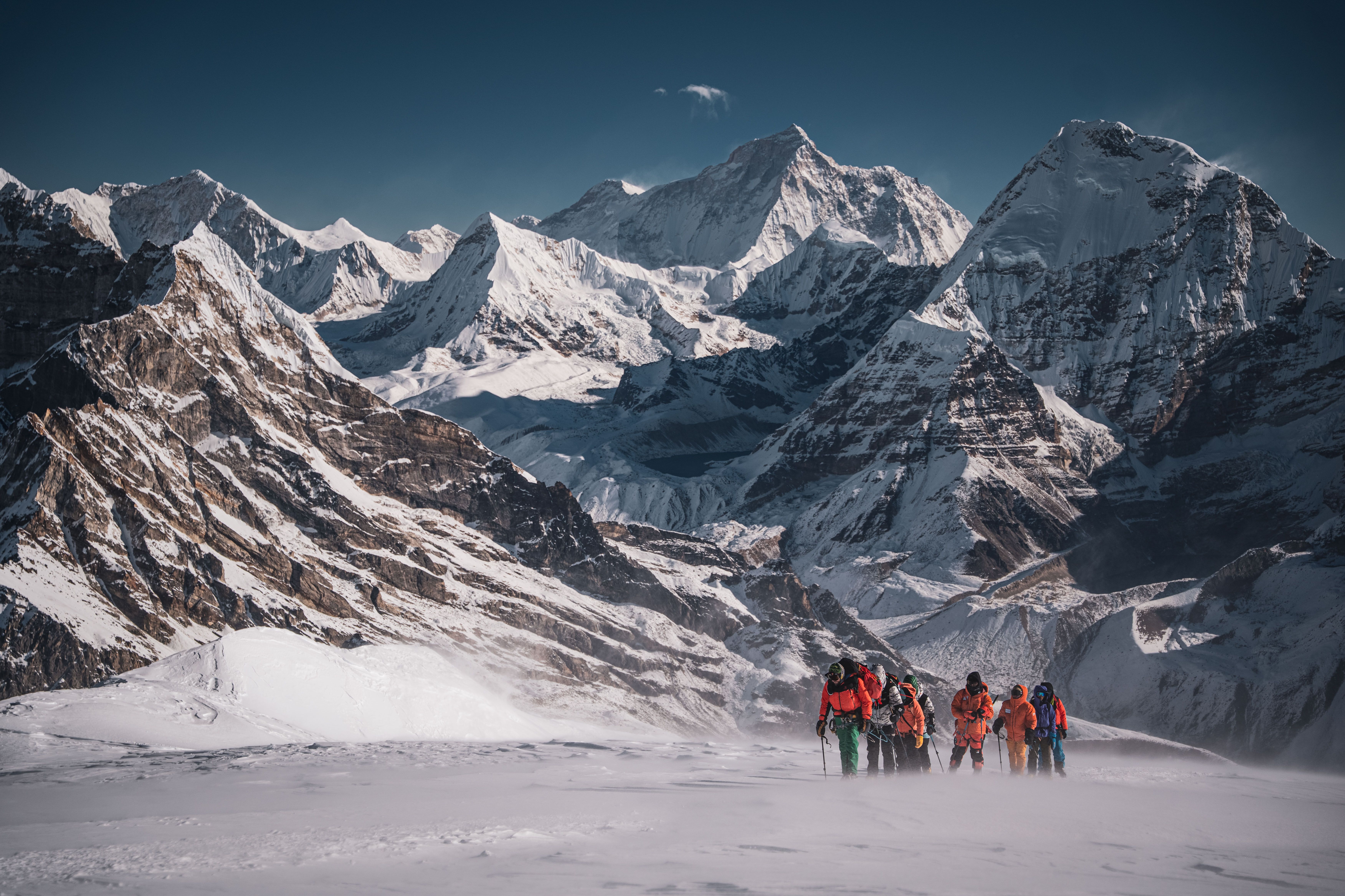
Snow-covered Himalayan peaks seen from the Mera Peak route
Ascent of Mera Peak, 6,461 metres

Nepal

Country

19 days

Duration

Mountaineering

Format

Hard

Difficulty

Alpine skills

Preparation level

About the program

Mera Peak is one of Nepal’s highest trekking peaks. Our objective is Mera Central, 6,461 metres. In clear weather, its slopes and summit offer views of five eight-thousanders at once: Everest, Lhotse, Makalu, Cho Oyu and Kangchenjunga. We will approach the mountain along a long southern route via Paiya, Pangom and Ramailo Danda. We chose this route because it is less crowded and allows us to gain altitude gradually. The route passes through the remote Hinku Valley and Makalu-Barun National Park. At first, we walk past agricultural terraces and through coniferous and rhododendron forests. Higher up, the forest gives way to alpine meadows. Then only moraines, glaciers, snow and rock remain. Trekking peaks in Nepal are an official category of mountains whose ascents are considered relatively straightforward from a technical standpoint. We will still need basic mountaineering training. We will travel over snow and a snow-covered glacier, wearing crampons and roped together, and use an ice axe, a Jumar ascender and a descender. Technically, Mera Peak is somewhat easier than the popular 6,000-metre peaks Island Peak and Lobuche Peak, but it is higher than both. You need to be prepared for a long approach, cold and an overnight stay at 5,800 metres. Beyond that, we will travel above 6,000 metres, where even simple actions require more time and effort. After the ascent, we return to Lukla by a different route, via Thuli Kharka and Zatrawa La Pass. This completes the loop of our route.

What to expect

❋

Ascent of 6,461-metre Mera Central

❋

Panorama of five eight-thousanders: Everest, Lhotse, Makalu, Cho Oyu and Kangchenjunga

❋

Remote Hinku Valley and Makalu-Barun National Park

Route by day

Arrival in Kathmandu

Day 1

Arrival in Kathmandu

We fly to Kathmandu, the capital of Nepal. Please arrive by 13:00 local time. A team representative meets participants at the airport. Once the group has assembled, we drive to Thamel, Kathmandu’s tourist district, and check in at the hotel. The city streets bring together Buddhist stupas, Hindu temples, markets, workshops and mountaineering-equipment shops. We meet for a group briefing: we get to know the team and review the route, altitude schedule, baggage arrangements and safety rules. We discuss preparations for heading into the mountains and leave time to rest after the flight.

Day 1Route day5-star hotel in Kathmandu, two-person occupancyAccommodation type1400 mMax altitude for the dayDinner at own expenseIncluded meals

Day 2

Kathmandu sightseeing and expedition preparation

Today we stay in Kathmandu. If you wish, you can explore the city and its sights; excursions and admission tickets are paid for separately. We devote part of the day to final expedition preparations. We check our personal and technical equipment: whether crampons fit mountaineering boots, and whether warm clothing, gloves, sunglasses, headlamps, sleeping bags and harnesses are ready. Any missing equipment can be purchased or rented. We complete the necessary permit arrangements and pack our baggage for the flight to Lukla.

Day 2Route day5-star hotel in Kathmandu, two-person occupancyAccommodation type1400 mMax altitude for the day
Flight from Kathmandu to Lukla. Trek to Paiya

Day 3

Flight from Kathmandu to Lukla. Trek to Paiya

We go to Kathmandu airport and fly to Lukla. The flight takes about 30–35 minutes: we cross the foothills and approach the main Himalayan ranges. We land at Tenzing Norgay and Edmund Hillary Airport. From Lukla, most travellers head to Namche Bazaar, Everest Base Camp, the Gokyo Lakes, Island Peak or Ama Dablam. We head south, towards the remote Hinku Valley. We first descend through forested slopes, passing small villages and agricultural terraces. Then the trail climbs again. Paiya lies lower than Lukla, but on the way there we will have to gain and lose elevation several times. The trek takes about 4–5 hours. We reach the village by evening.

Day 3Route dayLodge in Paiya, 2,730 metresAccommodation type2860 mMax altitude for the day8 kmRoute distance5 hrRoute time

Day 4

Trek from Paiya to Pangom

From Paiya, we continue along the southern route towards the Hinku Valley. The trail passes through forests, small mountain settlements and terraced fields. Sustained climbs alternate with descents to streams and rivers, followed by another climb. In spring, the area is green and the rhododendrons are in bloom. These are still Nepal’s humid foothills; the high-altitude section of the route lies ahead. Because of the constant elevation changes, this is a long trek. We walk at an easy pace so as not to overexert ourselves at the beginning of the program. By evening, we climb to Pangom, a small village away from the main tourist routes.

Day 4Route dayLodge in PangomAccommodation type2846 mMax altitude for the day10 kmRoute distance7 hrRoute time

Day 5

Trek from Pangom to Ramailo Danda

After breakfast, we leave Pangom and head east. We gradually gain altitude, crossing forested ridges, small settlements and agricultural terraces. Along the way, we pass mani stones, Buddhist symbols and small shrines. The villages become fewer, the lodges simpler, and there are noticeably fewer people on the trail as we move farther from the main tourist routes. In good weather, we will see the snow-covered massif of Mera Peak for the first time today. The summit is still several days away, but our mountain is already visible above the valley and becoming a landmark. At the end of the trek, we reach the forested ridge of Ramailo Danda.

Day 5Route dayLodge in Ramailo DandaAccommodation type3270 mMax altitude for the day7 kmRoute distance5 hrRoute time

Day 6

Trek from Ramailo Danda to Chhatra Khola

We trek from Ramailo Danda to Chhatra Khola through dense forest. The trail sometimes follows the river, then climbs above it and descends back into the gorge. Underfoot are streams, roots, stone steps and wet ground. After rain, it can be muddy and slippery, so we walk carefully. Trekking poles will be useful on steep, wet sections. Permanent settlements become fewer and farther between. We enter a remote part of the Hinku Valley, where it can take many hours to get from one small lodge to the next. By evening, we reach Chhatra Khola.

Day 6Route dayLodge in Chhatra KholaAccommodation type3150 mMax altitude for the day6 kmRoute distance4 hrRoute time

Day 7

Trek from Chhatra Khola to Kote

We climb through the valley via an old fir forest. Thick moss hangs from the branches, and rhododendrons grow between the trees. In places, almost no light reaches the ground. Farther on, the forest alternates with rocky slopes and open sections above the river. Himalayan martens, red pandas, musk deer and Himalayan pheasants live here. Encounters are rare; seeing any of them is a matter of luck. After several hours, we reach Kote, one of the main settlements in the Hinku Valley. The lodges here are noticeably more comfortable than at the previous stops.

Day 7Route dayLodge in KoteAccommodation type3600 mMax altitude for the day6.5 kmRoute distance5 hrRoute time
Trek from Kote to Thaknak

Day 8

Trek from Kote to Thaknak

From Kote, we climb up the Hinku Valley towards Thaknak. We gain altitude gradually, but the thin air is already beginning to make itself felt. The forest becomes lower and sparser, then gives way to shrubs, alpine meadows and open slopes. In good weather, Kyashar, 6,769 metres, remains in view almost all day. The mountain rises above the valley and helps us find our way to Thaknak. Along the way, we turn off the main trail to a small Buddhist gompa beside a rocky massif. Closer to the settlement, scree and moraines appear, and traces of glaciers become increasingly visible. By evening, we reach Thaknak.

Day 8Route dayLodge in ThaknakAccommodation type4300 mMax altitude for the day8 kmRoute distance5 hrRoute time
Acclimatization day in Thaknak

Day 9

Acclimatization day in Thaknak

After breakfast, we head out to one of the hills above Thaknak for acclimatization. We climb gradually, spend some time at the high point and return down. We spend the night in Thaknak: we climb higher and sleep lower to prepare for further altitude gain and the trek to Khare. In good weather, Mera Peak, Kyashar and Kusum Kanguru are visible from the high point. During the outing, the guide monitors the group’s pace and how each participant is coping with the altitude. After returning, we rest and prepare for the next trek.

Day 9Route dayLodge in Thaknak, 4,300 metresAccommodation type4900 mMax altitude for the day
Trek from Thaknak to Khare

Day 10

Trek from Thaknak to Khare

We leave Thaknak for Khare, the last permanent settlement before the mountaineering section of the route. On the way, we approach Sabai Tsho, a glacial lake at the foot of Kyashar. The lake is surrounded by moraine ridges and rocky scree. There are no more trees; we continue through a high-altitude valley, over moraines and rocky ground. We gain about 600 metres during the day. Because of the thin air, we move more slowly, and the trek takes time. Khare lies directly beneath the Mera Peak glaciers. Here we finish the trekking approach and begin preparing for the ascent.

Day 10Route dayLodge in KhareAccommodation type4900 mMax altitude for the day5.5 kmRoute distance4 hrRoute time
Acclimatization and technical training in Khare

Day 11

Acclimatization and technical training in Khare

We stay another day in Khare for acclimatization and technical training. After breakfast, we climb towards the glacier. We review how to adjust and use crampons, travel on snow and ice, use an ice axe and perform a self-arrest. We practise travelling roped together, ascending a fixed rope with a Jumar ascender and descending with a descender. We check that personal equipment is compatible. The exact exercises we do will depend on the condition of the slope, the weather and the group’s level of preparation. After training, we return to Khare. In the second half of the day, we rest, pack our high-altitude packs and check our equipment once more before setting out for high camp.

Day 11Route dayLodge in Khare, 4,900 metresAccommodation type5300 mMax altitude for the day
Trek from Khare to high camp, 5,800 metres
Snow-covered Himalayan peaks seen from the Mera Peak route
Trek from Khare to high camp, 5,800 metres

Day 12

Trek from Khare to high camp, 5,800 metres

We leave Khare for high camp. We first climb rocky slopes and moraine, then reach the glacier. We put on crampons, rope up and continue over snow and ice. We gain about 900 metres during the day. At this altitude, we move slowly: even simple actions take more effort. The glacier, rocks and snowy slopes of Mera Peak surround us. If visibility is good, a panorama of the Himalayas opens up. At camp, we rest and prepare our clothing and equipment for the nighttime departure. The guide conducts a final briefing and checks the crampons, harnesses, carabiners, ascenders, ice axes and headlamps once again. We have an early dinner and turn in. There will be little time to sleep: we set out for the summit deep at night.

Day 12Route dayTents shared by two peopleAccommodation type5800 mMax altitude for the day4.5 kmRoute distance6 hrRoute timeIncludedIncluded meals
Ascent of Mera Central, 6,461 metres
Climbers ascending a snowy slope on Mera Peak with Himalayan peaks behind them

Day 13

Ascent of Mera Central, 6,461 metres

We get up in the middle of the night. We have breakfast, put on our equipment and begin the climb by headlamp. We travel in crampons, roped together: the route follows a snow-covered glacier, mostly over broad snowy slopes. We keep a slow, steady pace. Above 6,000 metres, we do not speed up and conserve our energy for the descent. At dawn, if the weather is clear, the panorama of the Eastern Himalayas opens up behind us. From the upper section of the route, we can see Cho Oyu, Everest, Lhotse, Makalu and Kangchenjunga. The ascent from high camp to the summit takes about five hours. We stop briefly at the summit and begin descending. It is about two hours to high camp. There, we rest, have lunch, pack our things and descend to Khare—about another three hours to the lodge. It is a long day. The physical exertion is compounded by the altitude, cold and lack of sleep, and on the descent we still need to watch every step carefully.

Day 13Route dayLodge in Khare, 4,900 metresAccommodation type6461 mMax altitude for the day11 hrRoute time

Day 14

Descent from Khare to Kote

From Khare, we descend along the familiar route via moraines and alpine meadows to Thaknak. From there, we follow the Hinku River to Kote. We lose about 1,300 metres of elevation during the day. It gradually becomes warmer and the air denser. First shrubs appear, then we return to the forest. After several days among rock, snow and ice, we are back in a green valley.

Day 14Route dayLodge in Kote, 3,600 metresAccommodation type4900 mMax altitude for the day

Day 15

Trek from Kote to Thuli Kharka

We leave Kote towards Zatrawa La Pass. The climb is long and steep and will take effort. We walk through yew, fir and rhododendron forest. In places, we climb stone steps and cross wet ground. Gradually, the forest ends and we emerge onto open alpine slopes with views of the surrounding ranges. By evening, we reach Thuli Kharka, below Zatrawa La Pass. This is our last night before returning to Lukla.

Day 15Route dayLodge in Thuli KharkaAccommodation type4250 mMax altitude for the day7 kmRoute distance8 hrRoute time

Day 16

Zatrawa La Pass, 4,620 metres, and descent to Lukla

From Thuli Kharka, we climb to Zatrawa La Pass. Ahead lies one of the longest treks on the return route. Trail conditions depend on the weather: in April, snow and icy sections may remain on the pass. From the pass, the Lukla area is visible again. We begin a long descent, quickly lose elevation and return to the forest. We gradually approach populated areas and reach Lukla. Here we complete the hiking loop and finish the mountain section of the program. We rest in the evening.

Day 16Route dayLodge in Lukla, 2,840 metresAccommodation type4620 mMax altitude for the day10 kmRoute distance9 hrRoute time
Flight from Lukla to Kathmandu

Day 17

Flight from Lukla to Kathmandu

We go to Lukla airport and fly directly to Kathmandu. The flight takes about 30–35 minutes and is subject to weather conditions. On arrival, we transfer to the hotel and rest after the mountain section of the journey. In the evening, we can gather as a group for a final dinner or continue resting.

Day 17Route day5-star hotel in Kathmandu, two-person occupancy, 1,400 metresAccommodation type2860 mMax altitude for the day
Contingency day
Contingency day

Day 18

Contingency day

This day is held in reserve in case of bad weather or delays during the mountain section of the route. If everything goes according to plan, we spend a free day in Kathmandu. You can rest, walk around the city, visit Boudhanath Stupa, the Pashupatinath Temple Complex or the old city of Bhaktapur, and buy souvenirs and equipment.

Day 18Route day5-star hotel in KathmanduAccommodation type

Day 19

Flight home

We leave the hotel in time for our international flight. A transfer will take participants to Kathmandu airport for their flight home. The program ends here.

Day 19Route day

What is included

Included

  • Russian-speaking program leader
  • Local English-speaking mountain guides
  • Insurance for local guides and porters
  • One porter per participant
  • Carrying up to 20 kg of personal baggage per participant
  • All program transfers
  • Airport pickup in Kathmandu
  • Transfer from the airport to the hotel
  • Flight with a local airline from Kathmandu to Lukla
  • Flight from Lukla to Kathmandu
  • Transfer to Kathmandu airport on the day of departure
  • Two-person accommodation at a 5-star hotel in Kathmandu
  • 3–4 nights in Kathmandu, depending on the actual use of the contingency day
  • Two-person accommodation in lodges and guesthouses throughout the route
  • Two-person accommodation in tents at Mera Peak high camp
  • Breakfasts at the hotel in Kathmandu
  • All meals during the stay at Mera Peak high camp
  • Mera Peak climbing permit
  • Permits and fees for visiting Makalu-Barun National Park
  • Required route and local permits
  • Group equipment
  • Branded Sauvage Adventure merchandise

Not included

  • International flights to and from Kathmandu
  • Nepal visa
  • Participant’s personal medical and travel insurance
  • Lunches and dinners in Kathmandu
  • Meals at lodges and guesthouses during the trekking section of the route
  • Personal snacks and drinks
  • Alcoholic drinks
  • Tips for guides, porters and other staff
  • Internet access at the lodges
  • Charging phones, cameras and other electronics
  • Additional paid services at the lodges
  • Personal expenses
  • Additional nights in Kathmandu beyond the number included in the program
  • Single occupancy in Kathmandu or on the route
  • Expenses arising from changes to the program due to weather, transport, medical or other reasons
  • Excursions in Kathmandu and admission tickets to attractions

Required gear

Clothing

  • Down jacket (a down-insulated hooded jacket for ascents of 6000 m peaks).
  • Down sweater or a synthetic insulating layer
  • Fleece top
  • Hardshell jacket
  • Hardshell pants
  • Hiking pants
  • Fleece pants or lightweight down pants
  • Warm baselayers (top/bottom)
  • Lightweight/active baselayers (top/bottom)
  • Warm mountaineering socks — 3–4 pairs
  • Lightweight hiking socks — 3–4 pairs
  • Gaiters
  • Fleece or softshell gloves
  • Ski gloves
  • Mountaineering summit mittens for temperatures of −20 and below.
  • Warm beanie
  • Lightweight beanie
  • Cap or sun hat
  • Neck gaiter — 2
  • Hiking shirt or long-sleeve T-shirt — 2
  • Rain poncho.
  • Casual clothes for the days in Kathmandu

Footwear

  • Double mountaineering boots (examples: Zamberlan Denali, La Sportiva G2, Scarpa Phantom 6000).
  • Hiking boots for high-altitude trekking
  • Hiking shoes

Camping and sleeping gear

  • Expedition duffel — 120–150 L
  • Hiking backpack — 40–60 L
  • Sleeping bag (comfort temperature −7 to −10. Extreme temperature −30 or below)
  • Foam sleeping pad and an inflatable or self-inflating sleeping pad
  • Vacuum flask — 1 L
  • Wide-mouth water bottle — 1 L, 2 bottles (one is used for drinking and is very convenient for mixing isotonic drinks. The second can be used as a pee bottle if you do not want to leave the tent for a nighttime toilet trip).
  • Backpack rain cover.

Technical equipment

  • Climbing harness (also called a sit harness or safety harness).
  • Climbing lanyard — 2
  • Carabiners — 5
  • Climbing helmet
  • Mountaineering crampons
  • Ice axe
  • Handled ascender
  • Descender
  • Ice axe leash or accessory cord — 6–7 mm in diameter and 1.5 m long.
  • Telescoping trekking poles with wide wrist straps (for comfortable use with mittens)
  • Headlamp and spare batteries
  • Power bank — 2

Sun and wind protection

  • Mountaineering sunglasses with category 4 lenses
  • Ski goggles with category 2 lenses or higher, preferably category 3–4.
  • Sunscreen — SPF 50
  • SPF lip balm.

Hygiene and personal items

  • Toiletry bag (soap, toothpaste and toothbrush, deodorant, towel).
  • Personal first aid kit
  • Wet wipes

Nutrition and supplements

  • Isotonic drink mix or electrolytes to dissolve in water — we recommend bringing these for long hikes and climbing, especially in hot weather or when sweating heavily, to replenish salts lost through sweat.
  • Multivitamin and mineral supplement — according to your individual needs. If you take one on your doctor’s advice, bring enough for the entire trip.

Documents

  • Passport
  • Insurance
  • Hermetically sealed waterproof packaging for documents.

Frequently asked questions

Is trekking experience enough for Mera Peak?
  • You need not only experience of long treks, but also basic skills in moving in crampons and on a rope team, using an ice axe, ascending with a Jumar and descending on a rope. The sessions in Khare are intended to refresh these skills, not teach them from scratch. Experience above 4,000–5,000 m is desirable.
What should I bring rather than rely on renting?
  • High-altitude boots, crampons, a harness, a down jacket and a sleeping bag. Some items can be found in Kathmandu and Khare, but their availability and condition cannot be guaranteed in advance. It is best to assemble your kit before the trip using the program’s equipment list.
Will I be able to contact family every day?
  • Not always. Mobile coverage is available only on parts of the route and may disappear entirely higher up. Some lodges offer paid Wi-Fi and charging, but this does not guarantee a constant connection. Bring power banks and warn your family about possible breaks in contact.
What are the age restrictions?
  • The standard minimum age is 18. Applications from participants aged 16–17 are considered individually, and a parent or legal guardian must accompany them. There is no upper age limit: health, fitness and previous mountain experience are taken into account.
When might we have to turn back before the summit?
  • If continuing is unsafe because of the weather, route conditions, participants’ wellbeing or the group’s pace. The program leader makes the decision. Taking part in the trip does not guarantee reaching the summit.
How do booking, payment and cancellations work?

Start by submitting an application and waiting for approval from your trip manager. Pay the deposit within 5 days (120 hours) after your application is approved by the manager, and no later than the programme start. The exact deadline is shown on your trip status page. Your place is secured once we receive it.

The deposit forms part of the total trip price. The deposit pays for consultations, booking services with partners and organising the trip, so it is non-refundable if you choose to cancel your participation.

The remaining balance for your selected departure must be paid no later than January 26, 2027 at 11:59 PM (Astana).

If the deposit is received after the usual balance deadline, the balance is due by the end of the 10th working day in the Astana calendar following the deposit, capped at the programme start. The exact deadline is shown on your trip status page.

If your plans change, notify your trip manager that you wish to cancel. If you have already paid the remaining balance for the programme:

  • If the Company receives your cancellation notice at least 60 calendar days before the programme starts, the remaining balance paid is refunded in full.
  • If your cancellation notice is received fewer than 60 calendar days before the programme starts, actual, documented expenses incurred in preparing your trip and not covered by the deposit may be deducted from the remaining balance paid. If there are no such expenses, the remaining balance paid is refunded in full.

Amounts returned or due to be returned by partners are excluded from the calculation of deducted expenses. The Company’s fee is included in the retained deposit and is not deducted again.

Your trip manager checks the documents and confirms the refund calculation. If cancellation results from the Company’s breach of its obligations, the amount paid, including the deposit, is refunded in full. Refunds are paid within 5 working days in the Astana calendar from the date the grounds for the refund arise, without waiting for funds from the partner.

For full details, see Booking and Payment.